
An aerial photograph, probably taken during the 1920s, captures a Walton-on-Thames that is immediately recognisable and yet strikingly unfamiliar. Walton Bridge crosses the Thames, but beyond it lies a landscape of fields, trees and scattered buildings. Look closely and the photograph records one of the most important transformations in Walton’s history: the passage from a small riverside town surrounded by countryside to the predominantly suburban town of today.
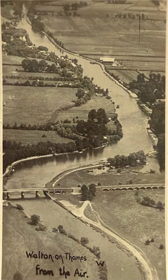
Walton Bridge is the first thing a modern resident is likely to recognise. The Thames curves through the foreground and the bridge crosses it towards Walton, but almost everything surrounding the crossing feels different. Roads are narrow, buildings are scattered, and large areas that a modern resident expects to see occupied by houses remain open land. The photograph’s exact date hasn’t been established, but this is Walton during a remarkable transitional period: the old rural landscape had not disappeared, yet the forces that would transform it were already at work.
Reading the photograph
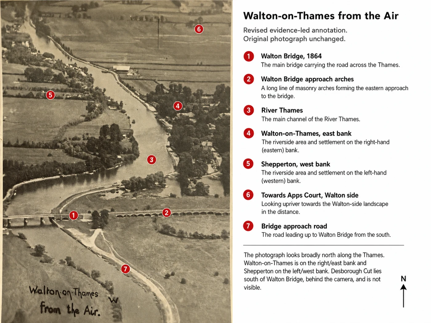
The camera appears to be looking broadly north across the Thames, with Walton on the right-hand, eastern bank and Shepperton on the left-hand, western side. The most important landmark is unmistakable: crossing the river is the third Victorian Walton Bridge, its central ironwork dating from 1864, when the damaged central spans of the earlier bridge were replaced following the partial collapse of the structure in 1859. Historic England’s own record of the failed stone bridge in its Henry W. Taunt Collection confirms exactly that sequence: a view of the bridge that collapsed in 1859, replaced by an iron bridge in 1864 (Historic England, n.d.).
Beyond the bridge, the landscape opens out towards the Walton side and the country around Apps Court. It’s the openness that is most striking. Modern Walton is embedded within a largely continuous belt of streets and housing stretching through Hersham, Weybridge, Molesey and towards Greater London. In this photograph, the settlement appears instead as something emerging from the countryside, with fields reaching remarkably close to the river and to the town. That is the real subject of the photograph.
A riverside town, not yet a suburb
Walton had existed for centuries before this photograph was taken, but for most of that history the countryside began almost at the town’s edge. Even after the arrival of the railway, nineteenth-century descriptions still presented Walton as a village. John Marius Wilson’s Imperial Gazetteer, published in the early 1870s, described Walton as a village standing beside the Thames, “a resort of anglers, tourists, and holiday parties.” The wider parish, which then included Hersham, had grown from 2,881 inhabitants in 1851 to 4,010 in 1861, an increase Wilson attributed specifically to new houses on the Oatlands Park estate and to the building of villas and ornamental cottages elsewhere (Wilson, 1870-72).
That description captures the beginning of the process visible in the aerial photograph. Walton was growing, but it had not yet been swallowed by its own suburbs. Elmbridge Museum describes Walton around the First World War in almost identical terms: “much smaller than it is now. Primarily rural with fewer roads and inhabitants” (Elmbridge Museum, n.d.). Contemporary photographs of the High Street and surrounding roads show a recognisable town centre, but one still closely connected to fields, estates and open countryside. The aerial photograph shows that relationship better than almost any street-level image could; from above, Walton’s rural setting becomes impossible to miss.
The railway had already started the transformation
The most important agent of change is not actually visible in the photograph. The railway arrived in Walton in 1838. Local landowners had resisted a route close to Walton’s historic centre, so the station was built some distance away, but the railway changed Walton’s future regardless: London was suddenly much easier to reach, and Walton could increasingly become a place to live while working elsewhere.
Elmbridge Borough Council’s own conservation area appraisal identifies the railway as exactly this kind of turning point: “The railway arrived in 1838 and due to opposition by local landowners it was positioned some distance from the centre of the town. From this time onwards, despite the lack of a close rail connection to the town, the area surrounding the historic centre of Walton grew substantially, with development infilling former fields, estates and parkland in all directions” (Elmbridge Borough Council, 2015). The effect was gradual rather than instantaneous, which is exactly why this photograph is so revealing: it catches the town after the railway had begun changing Walton, but before twentieth-century development had completed the transformation. The countryside had started to retreat, but it had not yet gone.
A town expanding into its fields
The change accelerated during the first decades of the twentieth century. Walton was increasingly attractive to people wanting access to London while living beyond the capital itself, and new roads and houses extended outwards from the older settlement, gradually joining areas that had once been separated by fields, gardens and private estates. By 1931, the population of Walton-on-Thames Urban District had reached 17,953, up from 14,644 a decade earlier and 12,856 the decade before that (University of Portsmouth, n.d.).
Population figures cannot convey the physical transformation as effectively as the photograph does. Every large field visible from the aircraft represents space in which Walton could expand; some would remain open because of the Thames floodplain or other constraints, while others would eventually disappear beneath streets, houses and infrastructure. The pattern continued through much of the twentieth century. Elmbridge Borough Council now characterises Walton as having a historic centre surrounded by “extensive residential suburbs predominantly dating from the early to late 20th century” (Elmbridge Borough Council, 2026). The modern suburban town was therefore not created in a single building boom. It accumulated: field by field, estate by estate, road by road, and the aerial photograph captures Walton while that process was still incomplete.
The Thames remained the constant
Through all of this change, the river retained the geography that had shaped Walton for centuries. The Thames had provided transport, recreation, employment and a natural boundary long before suburban development began, and Walton Bridge made that boundary easier to cross. The bridge itself provides another marker of change: its Victorian iron structure belonged to an era when horse-drawn vehicles still dominated Walton’s roads, yet increasing twentieth-century traffic would eventually overwhelm it. That Victorian bridge was hit during bombing in 1940 and left under weight restrictions for years afterwards; a deliberately temporary replacement opened alongside it in 1953, built to keep traffic moving while a permanent solution was worked out, and ended up serving for over three decades before a second temporary bridge arrived in 1999. The present bridge, intended this time as the permanent solution, opened in 2013 (Surrey County Council, 2010; see Walton Bridge: the story of six crossings for the fuller account).
Stand in approximately the same area today and the crossing is dramatically different, but the Thames is still there. Its floodplain has also prevented development from completely consuming the riverside landscape: Elmbridge’s own current planning guidance identifies the open flood plain to the north as “an important buffer” for the built-up area (Elmbridge Borough Council, 2026). The modern riverside therefore preserves fragments of the geography shown in the photograph, even though the town around it has changed almost beyond recognition.
Comparing Walton in 1920 and 1928
Other surviving aerial photographs help place this unidentified image in context. In June 1920, an Aerofilms aircraft photographed Walton Bridge and the grounds of Ashley Park; that image already shows a settlement expanding through a landscape in which large areas of open ground remained (Historic England, 1920). On 3 January 1928, another Aerofilms aircraft recorded extensive flooding around Walton Bridge (Historic England, 1928a), and later that year, in September 1928, Walton Bridge and Windmill Common were photographed from the air once again, along with a further shot of Walton town centre itself, houses and commercial buildings clustered around the historic road network while open land remains surprisingly close behind them (Historic England, 1928b; Historic England, 1928c).
Together these photographs provide useful comparison points for the unidentified view, and they reinforce the impression that it belongs to the 1920s, although an exact year cannot presently be justified. It’s best described as c.1920s, exact date unknown, rather than assigned a precise date on visual evidence alone. (For reference: the Desborough Cut lies south of Walton Bridge and therefore behind the camera in this view, rather than forming part of the landscape ahead. An early 1930s date can’t yet be completely excluded either.)
The countryside was closer than we remember
Perhaps the most revealing thing about the photograph is not any particular building. It’s distance. A resident could leave Walton’s streets and quickly find fields, river meadows, estates and agricultural land; the built-up area did not simply continue towards the horizon the way it does today. Walton has since become part of the wider suburban landscape of north-west Surrey, with roads leading almost continuously towards neighbouring settlements and housing occupying much of the land that previous generations would have understood as the countryside surrounding the town. The Walton of the photograph is clearly a town within a landscape; modern Walton can sometimes feel like a town within a much larger suburban landscape. That distinction is fundamental to understanding its twentieth-century history.
Yet old Walton has not vanished
The photograph can easily encourage a simple story of countryside lost beneath development, but the reality is more complicated. Parts of the historic settlement survive: the medieval origins of Walton can still be read around St Mary’s Church and the old road network, parts of the riverside retain a markedly different character from the later suburbs, and mature trees remain an important feature of the town. Elmbridge’s own current character assessment describes Walton as the largest town in the borough, yet also identifies surviving elements of the medieval settlement and what is locally known as Old Walton (Elmbridge Borough Council, 2026).
The modern town therefore contains both landscapes: the Walton created during centuries when agriculture, estates and the Thames dominated the local geography, and around it, another Walton, created largely during the nineteenth and twentieth centuries, when railways, roads, housebuilding and commuting transformed the relationship between Surrey and London. The aerial photograph captures the point at which those two Waltons overlap.
Why this photograph matters
Old photographs are often examined for vanished buildings. This one deserves to be viewed differently, because its importance lies in the spaces between the buildings. The fields tell us that Walton had not yet reached its modern extent. The narrow roads reveal a world before mass car ownership. The Victorian bridge connects the image to nineteenth-century Walton. The scattered development beyond it points towards the suburban expansion that would dominate the century ahead. And through the centre runs the Thames.
More than a century later, almost everything around that river has changed: the bridge and the roads have changed, thousands of houses have appeared, estates have disappeared, and fields have become streets. Walton itself has become one of Elmbridge’s largest towns. Yet the basic geography remains legible. The river still bends through the landscape, Walton still occupies its eastern bank, Shepperton remains across the water, open ground survives beside the Thames, and the bridge remains one of the principal gateways into the town.
That is what makes this photograph more than an attractive historic aerial view. It catches Walton in the act of becoming modern: the rural town has not quite disappeared, the suburb has not quite arrived, and for one moment, seen from the air, both are visible at once.
Sources
- Wilson, J. M. (1870-72) 'Imperial Gazetteer of England and Wales (Walton-upon-Thames entry), reproduced by A Vision of Britain Through Time'. Available at: https://www.visionofbritain.org.uk/place/270 ↗ (Accessed: 10 August 2026).
- University of Portsmouth (n.d.) 'A Vision of Britain Through Time: Walton upon Thames Urban District, Total Population 1911-1931'. Available at: https://www.visionofbritain.org.uk/unit/10041879/cube/TOT_POP ↗ (Accessed: 10 August 2026).
- Historic England (n.d.) 'A view of the stone bridge that collapsed in 1859; it was replaced by an iron bridge in 1864 (Henry W. Taunt Collection, AB0001/058A/02)'. Available at: https://historicengland.org.uk/images-books/photos/item/AB0001/058A/02 ↗ (Accessed: 10 August 2026).
- Historic England (1920) 'Walton Bridge and Ashley Park Grounds, Walton-on-Thames (Aerial photograph, EPW001720)'. Available at: https://britainfromabove.org.uk/image/epw001720 ↗ (Accessed: 10 August 2026).
- Historic England (1928) 'Flooding around Walton Bridge, Walton-on-Thames (Aerial photograph, EPW020203)'. Available at: https://www.britainfromabove.org.uk/image/epw020203 ↗ (Accessed: 10 August 2026).
- Historic England (1928) 'Walton Bridge and Windmill Common, Shepperton (Aerial photograph, EPW023463)'. Available at: https://britainfromabove.org.uk/en/image/EPW023463 ↗ (Accessed: 10 August 2026).
- Historic England (1928) 'The town centre, Walton-on-Thames (Aerial photograph, EPW023467)'. Available at: https://britainfromabove.org.uk/image/epw023467 ↗ (Accessed: 10 August 2026).
- Elmbridge Museum (n.d.) 'The Mount Felix War Hospital: Setting the Scene'. Available at: https://elmbridgemuseum.org.uk/online-exhibitions/the-mount-felix-war-hospital/ ↗ (Accessed: 10 August 2026).
- Elmbridge Borough Council (2015) 'Walton Church Street/Bridge Street Conservation Area Character Appraisal and Management Plan'. Available at: https://www.elmbridge.gov.uk/sites/default/files/2023-04/Walton%20character%20appraisal%20and%20management%20plan.pdf ↗ (Accessed: 10 August 2026).
- Elmbridge Borough Council (2026) 'Design and Character Supplementary Planning Document: Walton-on-Thames Companion Guide'. Available at: https://elmbridge.gov.uk/sites/default/files/2023-03/Companion%20guide%20-%20Walton%20on%20Thames.pdf ↗ (Accessed: 10 August 2026).
- Surrey County Council (2010) 'Walton Bridge Planning and Regulatory Committee Report'. Available at: https://mycouncil.surreycc.gov.uk/Data/Planning%20and%20Regulatory%20Committee/20100618/Agenda/Delegated%20Walton%20Bridge%20EL10%200824%20SP10%200311.pdf ↗ (Accessed: 10 August 2026).