1 The historic centre, Church Street and the riverside
Streets drawn: Church Street, Bridge Street, Manor Road
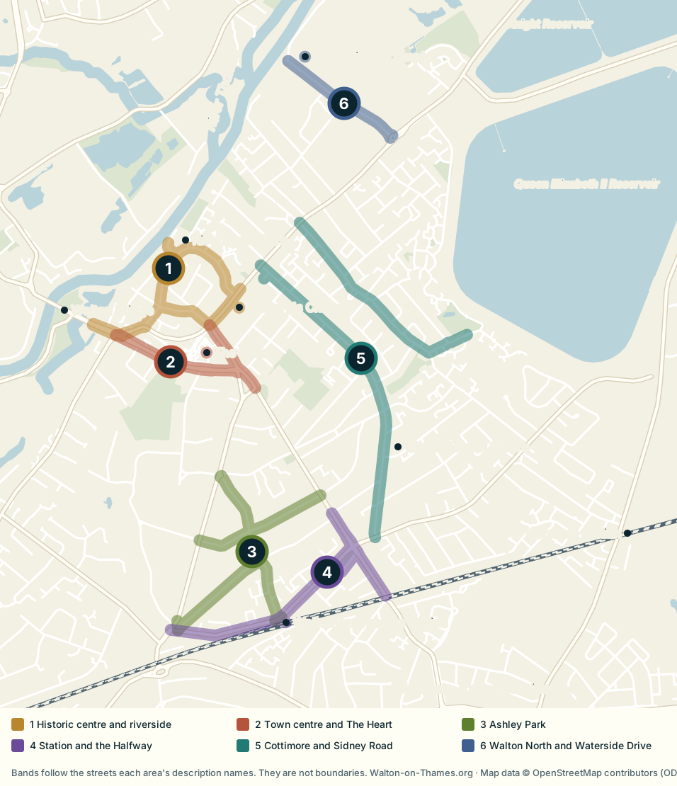
The oldest surviving part of Walton is around Church Street, Bridge Street, Manor Road and the Thames, with St Mary's Church and the Old Manor House within a compact area.
Two conservation areas cover it. Walton Church Street and Bridge Street, designated on 11 November 1974, is based on the historic road junction and includes the Grade I listed parish church of St Mary. Walton Riverside, designated on 1 December 1975, covers the area known locally as Old Walton and includes the Grade I listed Manor House (Elmbridge Borough Council, n.d.a; Ministry of Housing, Communities and Local Government, 2026).
Further reading: Walton Bridge · Riverhouse Barn · riverside walks
2 Walton town centre and The Heart
Streets drawn: High Street, New Zealand Avenue, plus The Heart
The modern commercial centre is focused on High Street, New Zealand Avenue and The Heart. On the map it sits immediately south of the historic core, close to it but distinct from it.
The Heart has shops, places to eat, a gym and Walton Library, with anchor names including Sainsbury's, Next and Waterstones (The Heart Shopping Centre, 2026). Many everyday needs can be reached on foot from the streets around it. It is also the most urban-feeling part of Walton, with more flats, traffic and commercial activity than the quieter residential streets farther out.
Further reading: The Heart · food and drink · history of the town centre
3 Ashley Park
Streets drawn: Ashley Park Road, Ashley Drive, Ashley Rise
Ashley Park takes its street pattern and its name from the former Ashley Park estate, which was broken up for development in 1923. Ashley Park Road, Ashley Drive and Ashley Rise occupy land once associated with the estate, and much of the interwar housing followed its sale (Hughes, 2003).
The map shows why it suits people who want both halves of Walton: the Ashley streets lie between the town centre and the railway station, with Ashley Park Road running up from the station towards the centre.
Further reading: the Ashley Park estate
4 The station, Halfway and Hersham Road
Streets drawn: Station Avenue, Halfway Green, and Hersham Road where it passes the Halfway
Walton-on-Thames railway station is not in the town centre. The walk to The Heart takes approximately 20 to 25 minutes, depending on route and pace, and the map shows the distance plainly (Walton-on-Thames.org, 2026a). The streets around Station Avenue, the Halfway and Hersham Road form a distinct station side, where the daily journey for a London commuter can be very different from the one made from the centre.
The station has two operational platforms, step-free access, cycle storage and paid parking (National Rail, 2026). It also serves north Hersham, whose own station appears at the right-hand edge of the map (Walton-on-Thames.org, 2026a).
Hersham Road runs south-east from near the town centre, through the Halfway, towards Hersham (OpenStreetMap contributors, 2026). Only the stretch at the Halfway is drawn in this band, so that it does not imply the station side reaches The Heart.
Further reading: Walton-on-Thames station guide · getting here
5 Cottimore, Sidney Road and the east of the town
Streets drawn: Cottimore Lane, Sidney Road
Much of this side of Walton was once the Walton Lodge and Cottimore estates. Research by local historian John A. Stonebanks shows how their land was sold and developed in the nineteenth and early twentieth centuries, while older carriage routes and estate names survived in the modern street pattern (Stonebanks, 1982).
Sidney Road is the clearest example. It runs between Terrace Road and Rydens Road (OpenStreetMap contributors, 2026), along the line of an earlier private carriage way, part of which was laid down as a regular road in 1867 to 1868 (Stonebanks, 1982, p. 13). On the map it is the long north to south band.
Walton Health Centre, on Rodney Road just off Sidney Road, is home to The Red, White and Yellow practices (NHS, n.d.a; NHS, n.d.b; NHS, n.d.c).
Further reading: Sidney Road and the Walton Lodge estate
6 Walton North and Waterside Drive
Streets drawn: Waterside Drive, plus the Xcel Leisure Complex
North and north-east Walton mix residential streets, open space and sports facilities, with routes towards the Thames and the reservoirs, which the map shows to the east.
The Xcel Leisure Complex and Sports Hub on Waterside Drive is the anchor, with a 25-metre pool, a sports hall, a floodlit athletics track and pitches (Elmbridge Borough Council, n.d.b). Housing character varies from street to street, so a label such as "Walton North" tells a buyer or renter less than looking at the streets immediately around a property.
On the official layers
Part of Waterside Drive and the Xcel leisure centre building lie inside the River Thames at Walton flood-warning area, which the Environment Agency describes as including the Elmbridge Leisure Centre (Environment Agency, 2026a; 2026b). Check any individual address with the long-term flood risk service ↗.
Further reading: Elmbridge Xcel Leisure Complex · clubs and societies
Hersham and Whiteley Village
Hersham adjoins Walton to the south-east. It is a distinct village with its own centre, green and station, not a seventh Walton area, which is why the map points towards it rather than drawing it (Walton-on-Thames.org, 2026b). Whiteley Village lies south of Hersham, beyond the edge of the map.
Hersham · living in Hersham · Whiteley Village
How this map was made
Every line on the map comes from open data, and a script rebuilds it from source, so it can be checked and updated rather than redrawn by hand.
- Streets, river, railway, reservoirs and landmarks come from OpenStreetMap, as at 16 September 2026 (OpenStreetMap contributors, 2026).
- Each area is a band 60 metres wide along the streets its description names, with a dot for any landmark it names. Where a street name also occurs in a neighbouring town, only the Walton stretch is used.
- Conservation areas are the boundaries the borough councils supply to the government's planning data service (Ministry of Housing, Communities and Local Government, 2026).
- The flood-warning area is the Environment Agency's own polygon for the River Thames at Walton (Environment Agency, 2026b).
- The statements under "On the official layers" were measured on the street geometry itself, not read off the drawn bands.
The map is accurate enough to show where places are in relation to one another, not to settle whether a particular property lies inside a line. For that, use the council's and the Environment Agency's own services. Our guide to living in Walton also mentions Field Common, but OpenStreetMap does not map it as a place, so it is not marked here.
Working out where to live
This page covers what each area is and where it sits. For what living in them costs and what to check before committing to an address, see the main guide: housing and the real cost of living, getting around and commuting, and the checks to make before choosing a property.
References
- Elmbridge Borough Council (n.d.a) Walton conservation areas. Available at: https://www.elmbridge.gov.uk/planning/conservation-areas/walton-conservation-areas ↗ (Accessed: 16 September 2026).
- Elmbridge Borough Council (n.d.b) The Xcel Leisure Complex and Sports Hub. Available at: https://www.elmbridge.gov.uk/sports-and-health/sports-venues/sports-and-health/sports-venues/xcel-leisure-complex-and-sports-hub ↗ (Accessed: 16 September 2026).
- Environment Agency (2026a) River Thames at Walton flood warning area. Available at: https://check-for-flooding.service.gov.uk/target-area/061FWF23Walton ↗ (Accessed: 16 September 2026).
- Environment Agency (2026b) Flood-monitoring API: flood area 061FWF23Walton, polygon. Open Government Licence. Available at: https://environment.data.gov.uk/flood-monitoring/id/floodAreas/061FWF23Walton/polygon ↗ (Accessed: 16 September 2026).
- Environment Agency (n.d.) Check the long-term flood risk for an area in England. GOV.UK. Available at: https://www.gov.uk/check-long-term-flood-risk ↗ (Accessed: 16 September 2026).
- Hughes, W. (2003) Images of England: Walton-on-Thames. Stroud: Tempus Publishing.
- Ministry of Housing, Communities and Local Government (2026) Planning data: conservation area dataset. Boundaries supplied by Elmbridge Borough Council and Spelthorne Borough Council. Open Government Licence. Available at: https://www.planning.data.gov.uk/dataset/conservation-area ↗ (Accessed: 16 September 2026).
- National Rail (2026) Walton-on-Thames (WAL). Available at: https://www.nationalrail.co.uk/stations/walton-on-thames/ ↗ (Accessed: 16 September 2026).
- NHS (n.d.a) The Red Practice Walton. Available at: https://www.nhs.uk/services/gp-surgery/the-red-practice-walton/H81094 ↗ (Accessed: 16 September 2026).
- NHS (n.d.b) The White Practice. Available at: https://www.nhs.uk/services/gp-surgery/The-White-Practice/H81131 ↗ (Accessed: 16 September 2026).
- NHS (n.d.c) The Yellow Practice. Available at: https://www.nhs.uk/services/gp-surgery/the-yellow-practice/H81095 ↗ (Accessed: 16 September 2026).
- OpenStreetMap contributors (2026) OpenStreetMap data for Walton-on-Thames, retrieved through the Overpass API. Data as at 16 September 2026. Open Database Licence. Available at: https://www.openstreetmap.org/copyright ↗ (Accessed: 16 September 2026).
- Stonebanks, J.A. (1982) Cottimore and Walton Lodge, Walton-on-Thames: An account of the two estates after the Inclosure of 1800. Walton and Weybridge Local History Society Paper No. 20.
- The Heart Shopping Centre (2026) The Heart, Walton-on-Thames. Available at: https://heartshopping.co.uk/ ↗ (Accessed: 16 September 2026).
- Walton-on-Thames.org (2026a) Walton-on-Thames Railway Station. Available at: https://walton-on-thames.org/walton-on-thames-railway-station/ ↗ (Accessed: 16 September 2026).
- Walton-on-Thames.org (2026b) Hersham. Available at: https://walton-on-thames.org/hersham/ ↗ (Accessed: 16 September 2026).
- Whiteley Homes Trust (n.d.) Whiteley Village. Admin Building, Octagon Road, Walton on Thames, Surrey KT12 4EH. Available at: https://whiteleyvillage.org.uk/who-we-are/whiteley-village/ ↗ (Accessed: 16 September 2026).